
- Home
- Resume, CV & Research
- Code & Other Work
- Pages

Resume, CV & Research
LinkedIn | www.linkedin.com/in/paulojraposo
Google Scholar | https://scholar.google.com/citations?user=WCF5qMAAAAAJ
ResearchGate | researchgate.net/profile/Paulo_Raposo2
ORCID |  orcid.org/0000-0002-0699-8145
Scopus | Author ID: 35278469500
I am a cartographer and geographic information scientist. My research interests are mainly in generalization and multiple representation of geospatial data and its illustrations, cartographic design, geometry, and GIS programming.
My current projects include work on flow map generation, discrete global grid systems, augmented reality cartography, and surface analysis and generalization. My work has focussed on generalization algorithm development and cartographic design, and I usually consider these two tied together tightly, such that outputs are well-suited to symbolization. My projects usually result in open-source code meant for both academics and production cartography.
I have taught courses in cartography, geographic information systems and science, and GIS software development at ITC, The University of Twente, The Pennsylvania State University, and the University of Tennessee, Knoxville.
Code & Other Work

Github Repositories | github.com/paulojraposo
GIS StackExchange | gis.stackexchange.com/users/40481/paulo-raposo
CartAGen's implementation of my hexagonal quantization algorithm for line simplification. By Guillaume Touya at IGN France.
My talk at NACIS 2017, covering work on automated flow map drawing and 3D holographic map visualization.
Tip on making wall maps from Esri's World Topographic Map, in ArcWatch e-magazine, coauthored with Aileen Buckley.
An Analysis of Canada's Vulnerability to Emerging Infectious Disease Threats via the Global Airline Transportation Network, a 2009 report to the Public Health Agency of Canada, including cartography of my design. Written by Bio.Diaspora (now Bluedot.global).
Sonic City, article by Richard Florida and Scott Jackson in the Journal of Planning Education and Research, 2009, featuring two of my maps (publisher access permission required).
Pages
Here you'll find a miscellaneous collection of teaching materials and my reflections and thoughts on creative, academic and scientific topics. The opinions here are my own.
- A tutorial on scripting with GeoPandas, using public Toronto tree data. - 2025-11-29
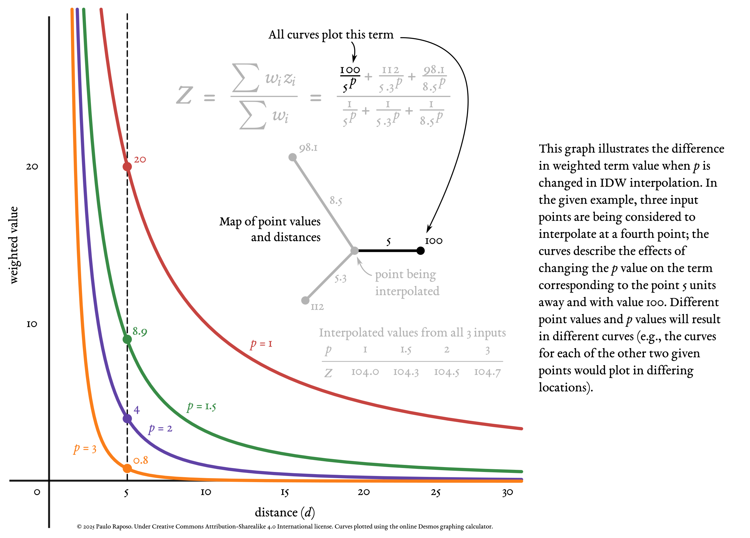
- Diagram on the effect of changing the p value in IDW interpolation. - 2025-02-10
- An introduction to table joins, and demonstration in QGIS. - 2023-08-13
- An introduction to the CityJSON format for 3D built environment data. - 2023-03-13
- A short video lesson on the Universal Transverse Mercator (UTM) coordinate system - 2022-10-26
- Calculating Chicago bikeshare trip durations and distances, and visualizing using kepler.gl - 2022-10-02
- An introductory tutorial on vector site suitability analysis for wind turbines - 2021-10-05
- An introductory tutorial on PDAL and LiDAR data processing - 2021-02-15
- How to Read Academic Papers and Chapters - 2019-05-20
- Diagram explaining Universal Transverse Mercator (UTM) zones (high-resolution PNG) - 2018
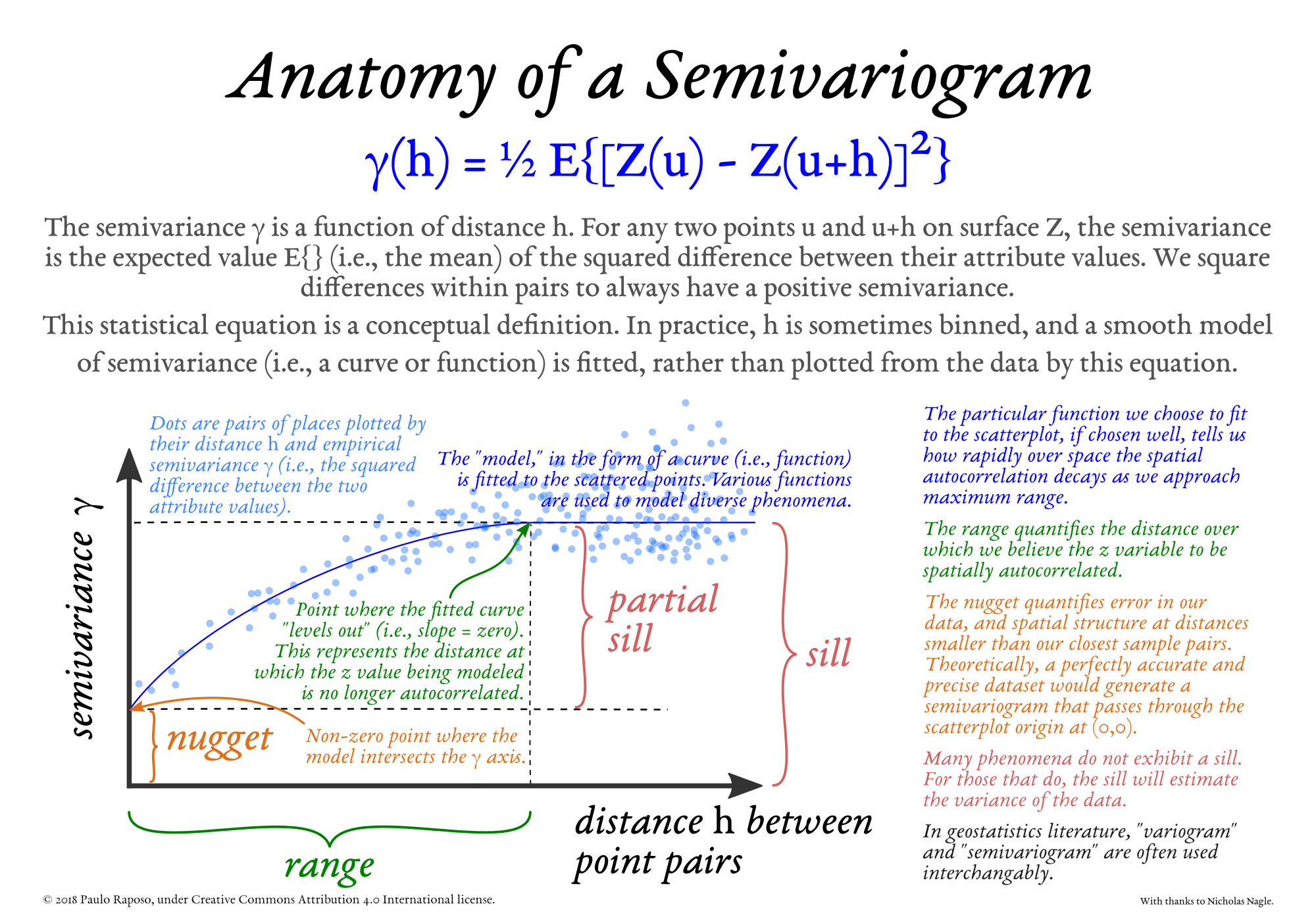
- Anatomy of a semivariogram, relevant to Kriging interpolation (high-resolution PNG) - 2018